")

")
")
Lake Skadar biking and hiking
Biking is one of the most popular activities in National Park Lake Skadar considering that tracks van be used all year round. Most of them are marked and easy to use by tourists. They run through picturesque villages and areas with ample vegetation.
Cycling tracks in Crmnica region:
1. Rijeka Crnojevica - Virpazar - Ckla
Length 65km, the highest climb 470m

2. Rijeka Crnojevica - Karuc
Length 9,5km, the highest climb 470m

3. Virpazar - Crmnicko field - Virpazar
Length 17,5km, the highest climb 260m

4. Virpazar - Limljani - Boljevici - Virpazar
Length 20km, the highest climb 375m
<p
5. Virpazar - Sutorman - Bar
Length 34km, the highest climb 730m

6. Dodoši - Žabljak Crnojevica
Length 10km, the highest climb 10m

We can always recommend You some other tours on your demand, mixed tours ( hiking and biking and swimming )... For Your safe trip we provide you all necessary equipment (spare tire, pump, tools, chain lock, map...). If You have any question about this subject don't hesitate to contact us.
Hiking is one of favorite activities in National Park Lake Skadar. In addition of large water surface of lake, National Park hides its stupendous hinterland which waits to be discovered. There are dozens of kilometers of marked trails along Skadar Lake andAdriatic coast.
Here are some hiking trails that we hardly recommend:
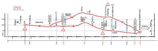
1. Trail 793 - Trough the Valey of River Orahovštica
Length: 13 km
Portal: Turning for Babin Bridge
Target: Sjenokosi (Opačac)
Midpoints: Dupilo (the Bridge of Mara Neškova), Opačac
Difficulty: Medium - hard ( Time: 5:00 h )
Altitudinal difference: Δh=39-200-101-96-30-39
Trail type: circular
Substrate: asphalt, rock, dirt road
Period of use: throughout the year.
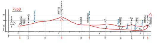
2. Trail 796B ( Zabes - Godinje )
Length: 4.5 km (Godinje 1.8 km)
Portal: The village Zabes
Target: Godinje (hamlet of Lekovići)
Midpoints: the viewpoint on Brčelice, hamlet of Nikači, Smolac (spring)
Difficulty: Medium - Hard (easy as a circular trail within Godinje)
Time: 4:00 h
Altitudinal difference: Δh012-94-270-102-28
Trail type: linear (circular in Godinje)
Substrate: rock, earth, asphalt
Period of use: throughout the year.